Astronomy Picture of the Day
Discover the cosmos!
Each day a different image or photograph of our fascinating universe is
featured, along with a brief explanation written by a professional
astronomer.
June 24, 1996
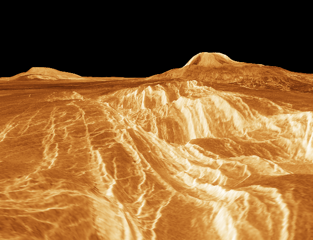
A View from Venus: Rift Valley
Credit:
The Magellan Project,
JPL, and
NASA
Explanation:
Color information from the
Soviet Venera landers and radar data from
the Magellan spacecraft
were used to construct this striking perspective view of the
Venusian landscape. (In this computer
generated image, the vertical scale has been exagerated.)
In the foreground is the edge of a rift valley created by faulting in
the crust of
Venus.
The valley runs all the way to the base of
Gula Mons, a 2 mile high volcano seen here on the right,
some 450 miles in the distance.
On the left is another volcano, Sif Mons.
Using radar to pierce the dense clouds continuously shrouding
the Face of Venus, Magellan was
able to explore over 98% of the Venusian surface, revealing a a diverse and
tantalizing topography.
Tomorrow's picture: A Star Forming Region in the LMC
| Archive
| Index
| Search
| Glossary
| Education
| About APOD |


Authors & editors:
Robert Nemiroff
(GMU) &
Jerry
Bonnell (USRA).
NASA Technical Rep.:
Sherri
Calvo.
Specific rights apply.
A service of:
LHEA
at
NASA/
GSFC